
GEO-NET at the WindEurope in Madrid
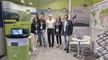
The wind energy sector is gathering in Madrid, and GEO-NET Umweltconsulting GmbH is right in the heart of it!
From 21 to 23 April, the WindEurope Annual Event 2026 will focus entirely on the future of renewable energy. We look forward to presenting our latest solutions in the areas of wind and energy yield assessments, wind potential analyses, wind measurements using masts and/or LiDAR, 200m LiDAR verifications and much more in the field of wind resource assessment.
Why you should visit us:
• Networking: Let’s discuss the latest trends and challenges.
• Expertise: Find out how GEO-NET Umweltconsulting GmbH can support your wind energy projects.
Where can you find us?
Visit us at our stand: 10-B40.
Johannes Becker, our new Managing Director, will also be present, alongside Carina Cerno and Judith Marquardt-Bach (Europe, South America and South Africa, Asia), Salem Malek (MENA region) and Sergei Roife (Ukraine and Central Asia).
GEO-NET is on Tour
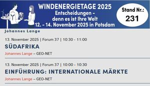
We’ll be there! From November 12–14, GEO-NET Umweltconsulting will be represented by 15 colleagues at the Wind Energy Days in Potsdam. Stop by our booth, No. 231—we look forward to engaging discussions and connecting with you in person! Don’t miss it: On November 13, @Johannes Lange will moderate the International Forum (Forum 37) for anyone interested in international markets and topics—it’s definitely worth checking out!
GEO-NET will once again be exhibiting at Husum Wind 2025
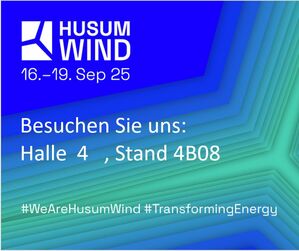
The coming week promises exciting insights and valuable discussions. We look forward to networking with you and discovering together the new opportunities the wind energy industry has to offer. Visit us at our booth, and let’s shape the future of wind energy together and stand united as an industry! We are especially pleased that Dominik Adler and Johannes Becker will be attending HUSUM WIND for the first time in their new roles as managing directors.
GEO-NET sets the Course for the Future with a Leadership Transition
Hannover 26.08.2025
GEO-NET Umweltconsulting GmbH has set the course for the future. As part of a carefully planned succession plan, Dominik Adler, Johannes Becker, and Dr. Björn Büter—authorized signatories who have been with the company for many years—are taking over the company together with Vidia Equity, a founder-led investment firm. Vidia invests in medium-sized companies in the fields of renewable energy/electrification, the circular economy, and industrial materials to scale their contribution to decarbonization. This combination of proven expertise and strategic partnership ensures continuity in management while laying the foundation for the company’s sustainable growth.
The founders and former managing partners, Peter Trute and Thorsten Frey, have decided to hand the company over to capable hands after many years of successful leadership.
“We are pleased to have arranged the succession in such a responsible manner,” say Peter Trute and Thorsten Frey. “Our goal was to find partners who share our company’s values and set the course for a successful future. We would like to take this opportunity to express our sincere thanks to the GEO-NET team for the many years of successful collaboration and your dedication.”
Stephan Rosarius of Vidia and the new managing directors Dominik Adler, Johannes Becker, and Dr. Björn Büte
About Vidia
Vidia is a founder-led private equity firm based in Munich, with an investment focus on companies that offer climate solutions in three core segments: electrification, the circular economy, and industrial materials. Within these segments, Vidia invests in successful mid-sized companies with the goal of fostering their growth through financial and operational support and scaling their respective climate solutions to help decarbonize the economy.
GEO-NET Offers New Extreme Wind Estimation for Wind Energy Projects
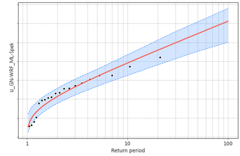
GEO-NET Umweltconsulting GmbH is expanding its portfolio with a new service: site- and hub-height-specific extreme wind assessments for wind energy projects throughout Germany.
An extreme wind analysis is required as part of a structural stability analysis. If a comparison of wind zones based on the DIBt wind zone map and the published wind zone in the design of the planned wind turbine type is unsuccessful or not possible, and if the design value is also exceeded according to the calculation method specified in DIN 1991-1-4 NA—based on the wind zone and terrain category data at the project site— a more precise estimation of extreme wind is required to verify whether structural stability is ensured. This is carried out as part of an extreme wind estimation service newly developed and offered by GEO-NET. This allows you to obtain both the structural stability analysis and the extreme wind estimation from a single source, saving you time and reducing communication efforts.
The new product from GEO-NET Umweltconsulting GmbH is based on a spatially representative 20-year time series of wind data, which is derived from a simulation using the mesoscale WRF model with a resolution of 3 km and was processed using a proven method based on machine learning and a spectral method. This GN-WRF_ML-Spek time series enables a realistic representation of wind conditions over two decades with a temporal resolution of 10 minutes. The extreme wind estimation is based on a method of extreme value statistics, assuming stochastic behavior of the event under investigation. Annual wind speed maxima are extracted from the underlying GN-WRF_ML-Spek time series, and it is assumed that the extracted maxima can be described using the Gumbel distribution, which is widely used in the industry. The extreme wind is estimated based on the Gumbel distribution fitted to the extracted maxima. To validate the results, the method was internally validated at 60 real measurement sites in Germany. As part of the in-house validation of the extreme wind determination, a scaling factor was determined that is taken into account when calculating the extreme wind. This factor incorporates a safety margin of half a standard deviation to adequately account for the uncertainties in the model chain.
The new product offers numerous advantages:
Location- and hub-height-specific extreme wind estimates using the high-quality GN-WRF_ML spectral time series
An extreme wind analysis may be required as part of the structural stability verification. GEO-NET offers you everything from a single source
Feel free to contact us about our new product: wind@geo-net.de
GEO-NET with a booth at Mining Indaba 2025 in Cape Town
Just like last year, GEO-NET will once again be participating in the German joint booth at the Mining Indaba from February 5–8 at the CTICC in Cape Town. Please visit us at our booth, R30 24. We analyze wind potential at mining sites and help mine operators decarbonize their operations and save on electricity costs. We are also happy to work with project developers who have already partnered with mining companies to form a project company for wind energy generation, or who plan to do so in the future. We look forward to seeing YOU!
Energy Yield Analyses Taking Climate Change into Account

GEO-NET Umweltconsulting GmbH of Hanover (GEO-NET) can now, at the client’s request, conduct wind energy yield analyses that take various climate scenarios into account.
Not least due to climate change, efforts to expand renewable energy are being accelerated. GEO-NET plays an important role in financing wind energy projects by providing bankable reports and conducting measurement campaigns.
Over the past year, the question of how climate change will affect the energy yield of wind farms over their operational lifespans has been raised with increasing frequency at various conferences and industry meetings. Furthermore, the BWE Standard for a Well-Managed Wind Farm with Direct Financial Citizen Participation, published by the German Wind Energy Association (BWE) in November 2022, requires that future developments such as climate change be appropriately described and adequately taken into account when preparing wind and yield assessments. To forecast how climate change will affect meteorological variables and, consequently, the output of wind farms, GEO-NET has therefore added a dedicated service to its product portfolio.
This service is based on coupling coarse-grained climate models with the FITNAH-3D CFD model, which has been tried and tested over many years and is continuously refined. Regional climate projections from the CORDEX initiative for various RCP (Representative Concentration Pathways) scenarios are used for this purpose.
LiDAR Performance Verification Mast
A 200-meter-high reference wind measurement mast for research, development, and LiDAR verification near Hanover
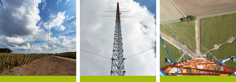
Since September 2022, we have been operating a new 200-meter wind measurement mast near Hanover for the verification of LiDAR and SoDAR devices. The site offers numerous advantages: It is centrally located, easily accessible via the A2, A7, and A27 highways, and provides good wind conditions. This allows GEO-NET to perform verification more quickly, and the verified devices can begin actual measurements sooner.
GEO-NET offers verification at fixed prices as well as part of a comprehensive package that includes a wind measurement campaign, yield assessments, and turbulence reports, with a consistent focus on the smooth and time-optimized execution of the entire package.
GEO-NET is a member of MEASNET

GEO-NET has been a MEASNET member in the area of site assessment since July 2020. MEASNET (International Network for Harmonized and Recognized Measurements in Wind Energy) is an international consortium of various measurement institutes that, on the one hand, jointly develop procedures and standards for site analysis and evaluation, and, on the other hand, commit themselves to adhering to these standards. These procedures are designed to ensure high data quality and good comparability.
Participation in the MEASNET Site Assessment expert group offers the opportunity to actively contribute to the design and further development of the standards. With our expertise and experience from over 3,000 projects worldwide and numerous research projects, we can help ensure that MEASNET-compliant reports will continue to guarantee safe and reliable site assessments in the future and will be recognized internationally by banks and investors.
LiDAR Error Correction in Complex Terrain Using FITNAH-3D
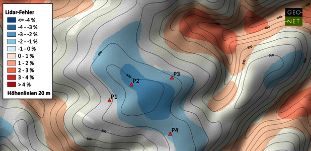
LiDAR devices are becoming increasingly popular for wind measurements: these compact devices are much easier to set up than a traditional wind measurement mast, do not require a building permit, and are easier to maintain.
In complex terrain, however, the devices have a systemic disadvantage stemming from their measurement principle: wind speed is measured using multiple laser beams that are angled at specific intervals relative to one another and point in different directions; wind speed and direction are then calculated using vector analysis. This works only as long as the wind field is homogeneous in all directions. In complex terrain—for example, when the wind flows over a hill or a ridge—this homogeneity is no longer present, leading to measurement errors.
GEO-NET can calculate this error in advance, thereby identifying the LiDAR location that produces the smallest measurement error and correcting the measurement error in the actual results. The three-dimensional flow model FITNAH-3D is used for this purpose, a model that has proven particularly effective in complex terrain. Using this model, GEO-NET generates a map showing the deviations of a LiDAR measurement from the actual wind speed. This map serves as the basis for selecting the measurement location and for subsequent error correction. In this way, the uncertainties of a LiDAR measurement in complex terrain can be significantly reduced.
Trade Shows and Events
- Windenergietage, 10.-12.11.2026, Linstow
- WindEurope Annual Event, 20.-22.04.2027, Kopenhagen